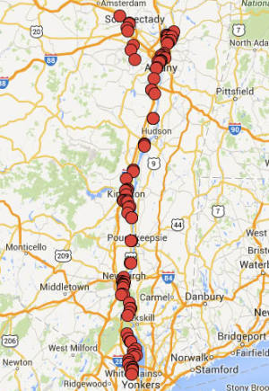
Map shows 100 schools along crude oil train tracks
On July 6, 2013, a train hauling more than 70 cars filled with volatile crude oil derailed in Quebec, Canada, after its engine caught fire and power to its air brakes was cut. Several DOT-111 oil tankers filled with crude mined from South Dakota”™s Bakken Shale ignited, spilling oil and sending a fireball into the sky of the town of Lac-Mégantic that destroyed 30 buildings, according to reports.
Forty-seven people died. Several thousand more were evacuated while oil seeped into the soil and local waterways. The Quebec derailment and several other disasters have brought increased scrutiny on the transportation of crude oil by rail as the amount of oil mined domestically continues to multiply.
New maps from state environmental groups show there are more than 100 public and private K-12 schools within a mile of train lines used to transport crude oil through the region. Albany-based Healthy School Networks released the maps last month in partnership with a coalition of environmental and education activists.

“They are crossing from Buffalo through Rochester and from the upper reaches of Lake Champlain and the Adirondacks to the Port of Albany, then down along the Hudson River,” Claire Barnett, executive director of Healthy Schools Network, said. “A catastrophic event, should it happen near an occupied school, could devastate a community for a generation or more.”
From 15 to 30 trains carrying crude out of South Dakota travel through the Hudson Valley region each week. Each train can haul dozens or as many as 100 oil cars, each that carry tens of thousands of gallons of the Bakken crude, which experts say is more volatile and unstable than other forms of oil. Oil is also transported by barge on waterways through the region and plans are in the gestation phase to begin transporting other types of crude through the area by rail as well.
The maps also included BOCES schools. Statewide, the maps identified 351 schools within one mile of train lines. In Monroe County alone, in the Rochester area, 63 schools were within the one-mile zone.
Environmental group Riverkeeper prepared an additional several maps depicting the potential impact area of local crude oil accidents based on the 300-yard blast radius and 1,100-yard evacuation zone from the Quebec derailment and a Casselton, N.D., derailment that spilled more than 400,000 gallons of crude.
“Based on the human consequences of these two accidents, it is clear that communities on both sides of the Hudson River could be impacted by a crude oil rail disaster,” said Kate Hudson, Riverkeeper”™s Watershed Program director.
A CSX Corp. rail line runs from Albany to the state”™s border with New Jersey. Land trust organization Scenic Hudson said that 47.7 miles of that track are within yards of the Hudson River. The group estimates the risk area in the event of a derailment would be more than 200,000 acres and include 100,000 households and six drinking water intakes.
The U.S. Department of Transportation Emergency Response Guidebook recommends a half-mile evacuation zone for accidents involving rail cars with flammable liquids and a mile zone around any rail car filled with those materials if they are on fire.
Environmental groups are calling for state and federal government reforms. These include asking government officials to provide emergency planning aid to schools, reduce speed limits for crude oil trains and impose stricter regulations and inspections for deteriorating DOT-111 tankers. The U.S. Department of Transportation is considering stricter regulations of the cars, but environmental groups have said the proposed laws don”™t go far enough.
The state has increased its inspection of cars in response to recent derailments, but oil industry experts look to continue to expand their processing capacities as the amount of crude mined through hydraulic fracturing surges. The amount of Bakken moving through the U.S. has risen from 9,500 rail carloads in 2008 to 415,000 rail carloads in 2013, according to the Department of Transportation.